 |
| Building Route 128, (Courtesy MHD) |
I am generally fascinated with infrastructure, current and those left to battle time; extra attention is paid these days the older I get and witness new development or re-purposing. I was driving around today enjoying the weather and thinking about a book
that I have read several times detailing the construction of Route 128 aptly titled
Building Route 128. For those not familiar with which I speak, Route 128 (I-95 and I-93 designations for significant amount of its length) is a circumferential highway outside of Boston going from Gloucester in the north to Braintree in the south. The stretch from Gloucester to Peabody is where Route 128 has a solo designation. So in my travels, I was passing
one of the abandoned "Old Route 128" stubs (Blue Hill River Rd.) in Braintree that has been incorporated into the Blue Hills Reservation trail system and two and two were put together. I have long neglected this area in terms of exploration especially as it related to my pet infrastructure/road interest. So, I parked the car and did some walking.
It must be said that I have an unexplainable obsession with this route designation. Maybe it stems from 128's status as the Silicon Valley of the East (although other locations vie for this "title"), or it's wrong way concurrences, abandoned road stubs of I-95 and Route 3. It could be said it is because I still get a chuckle confusing out of towners by calling stretches that have been renamed I-95, "Route 128", when there are no visible indicators to that designation (Masshole?). Maybe it is because I grew up traveling this route designation in various capacities (still do) and have watched over 30 years of development; but it is not really any of those. I will call it metaphysical and move on.
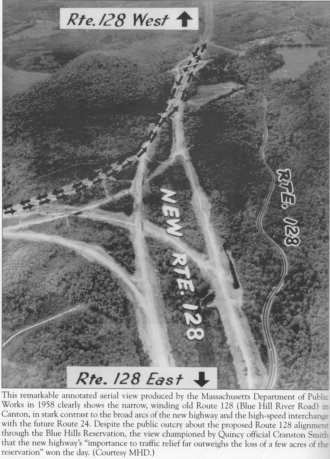
As it relates to "Old Route 128", there are sections that were incorporated into the current 128 and many sections that remain as they always were: a patchwork of surface streets from Gloucester to Hull in a circumferential pattern. It is an interesting process trying to retrace the steps of the original route; you can do a lot of it, but in some cases it is just not possible. One case in point is the section I have been most interested in. This includes the towns of Westwood, Canton, Milton, Randolph and Braintree and encompasses two roads: Blue Hill River Rd. and Greenlodge St. In this area, there are several sections (active and abandoned) easily traversed in a car; other sections you are on foot.
 |
| Old 128 looking towards West St., Braintree |
This brings us back to today and being on foot in the Braintree section of "old 128". On satellite view, this section's path is mostly visible and you can see where the current 128 (I-93) cuts through. If you are up for fighting flying insects pounding at you, it is an interesting walk. Double lines dividing the road are still visible and the roadway is not broken up. That is until it was intentionally broken up and reclaimed by nature. There are paths (including the Yellow Dot Trail) that run along side the old roadbed. However, there came a point which it was not passable and follow the roadway. That point comes before you reach the boundary with the highway.
After that, I though I have to walk the other end of this section of old 128. I was very much aware that part of the "abandoned" section in this area was an access road to additional parking and athletic fields at Houghton's Pond, but never really though much about the potential gem of the rest of this road. So, due to the fact that there was a major highway bisecting Blue Hill River Rd. (old 128), a drive of 4.5 miles was required to the spill over parking lot at Houghton's Pond. In the first picture of the post, you see the "Houghton's Pond" section
of Blue Hill River Rd. to the right and how it is cut off from the
Braintree section. Furthermore, if you are not looking for it, it will not be found as access is behind a gate (you are definitely not trespassing) and for about 500 feet the road has been ripped out giving no hint of what is beyond and a gravel path overgrown with grass is there in it's place.
 |
| Old 128 in Canton |
Again via satellite and first photo, the path Blue Hill River Rd. took is plain to see. When walking it, it is pretty surreal. The gravel path turns into roadway and you are on a meandering walk of about 1 mile until you reach a fence and the embankment of the highway. A lot of things go through your head in terms of history, the travel this road once saw, and the isolation this walk provides. However, for a good portion of the walk, the faint roar of automobiles is still audible. You are also fighting dive-bombing insects until you get closer to the highway. It is not as bad as it sounds and in exchange you see some interesting things (road markings, tests perhaps?) and amazing things (lines of younger trees bent to the center of the road, trying to skirt their bigger brethren for sunlight). Various trails now intersect this forgotten roadway so I could imagine this being quite a surprise to stumble upon coming out of the inner forest areas. In my total travels I only encountered one other person. This was an elderly fellow walking his dog. For all I know he used to walk along the road when cars ran through here. Nevertheless, one of things I am not 100% sure on is when this section of road was closed to traffic, but I presume it was the mid 1950's. I have done the Greenlodge section many times and have a number of photos of this area which some are on Flickr. I have put them all into a new album.
(HERE)
Moreover, because today was an impromptu visit to the Blue Hills area, I did not have my camera. However, I did have my rinky-dink cellphone cam so I could share the experience in some way and hope the quality is good enough for you to get a sense. If not, I guess you need to go see for yourself and bring repellant. Either way, a return visit is on the cards for me.

Came across this area of the park while running a solo marathon due to COVID-19. One of the most amazing, surreal places I've ever encountered in a state park.
ReplyDeletePretty awesome.
Delete